Wapda Town Lahore Map – Phase 1, Phase 2 & Block-Wise Layout Guide
A complete, easy-to-read location guide covering every phase, block, access road, and nearby landmark in Wapda Town — built for buyers, investors, and residents planning a visit.
Reading the Wapda Town Lahore Map
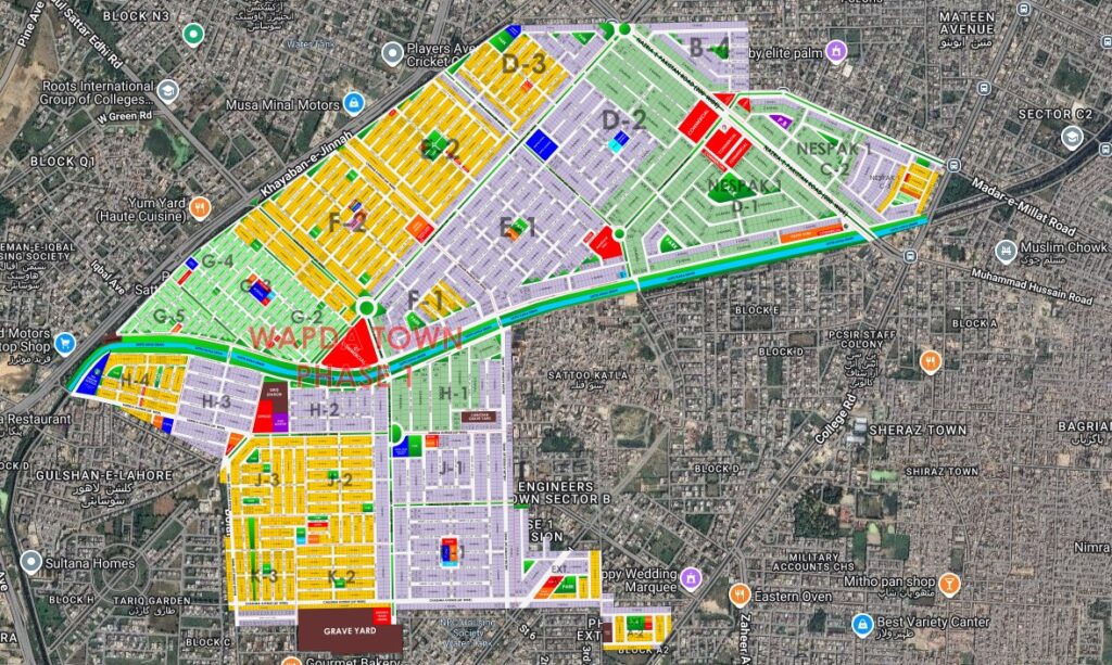
Anyone searching for a reliable Wapda Town Lahore map usually has one of three goals in mind: locating a specific block before a site visit, comparing Phase 1 against Phase 2 before making a purchase decision, or simply working out how to reach the society from another part of the city. This guide is built around all three needs, starting with an embedded map view followed by a full phase and block breakdown.
Wapda Town sits in a well-established part of Lahore, close to Multan Road and within easy reach of Thokar Niaz Baig, which is why its layout is one of the more frequently searched location references among people evaluating property in this part of the city. The society follows a grid-like block structure, with wide internal roads, roundabouts at major junctions, and clearly numbered blocks that make navigation straightforward once you understand the pattern. New visitors often find it helpful to first identify the main boulevard, since almost every block can be reached by following one of the connecting roads that branch off from it.
This kind of clarity matters more than it might seem at first. A housing society with confusing or poorly signposted blocks can turn a simple property visit into a frustrating afternoon of wrong turns, especially for buyers coming from outside the immediate area. Wapda Town avoids most of that friction thanks to its consistent block-numbering system and well-maintained internal roads, which is part of why it remains a popular reference point for people comparing several societies along the Multan Road corridor before settling on one.
© Wapda Town Lahore Map – Provided by ilaaqa.com
Phase-Wise Breakdown: Phase 1 vs Phase 2
Wapda Town Lahore Phase 1 Map Overview
Phase 1 is the older, more established section of the society, developed first and now almost fully built up. Its blocks are arranged around a central commercial spine, with mature trees, developed parks, and a settled residential character. Most people looking for a map of Wapda Town Phase 1 Lahore are checking block boundaries for resale plots or confirming distance to the main boulevard before visiting a house.
| Block Range | Character | Typical Plot Sizes |
|---|---|---|
| B–F | Fully developed, close to main boulevard | 10Marla, 1 Kanal & 2 Kanal |
| G – J | Mixed residential, near parks | 5, 10 Marla & 1 Kanal |
| K1 – K3 | Quieter interior blocks | 5 & 10 Marla |
Wapda Town Lahore Phase 2 Map Overview
Phase 2 is the newer extension, offering wider roads and a more modern block layout compared to Phase 1. A map of Wapda Town Phase 2 Lahore typically shows larger green belts and a slightly less dense residential footprint, which appeals to buyers who want a quieter setting while staying within the same society network and access points as Phase 1.
| Block Range | Character | Typical Plot Sizes |
|---|---|---|
| P1 – P4 | Newer construction, wider streets | 10 Marla & 1 Kanal |
| Q1 – Q3 | Emerging blocks, lower density | 5 & 10 Marla |
Block K2 and Other Key Reference Points
Among the most frequently referenced sections is Block K2 — a Phase 1 block that sits close to internal commercial markets and is often used as an orientation point when giving directions to visitors unfamiliar with the area. When someone asks about this block specifically, they’re usually trying to locate a plot near its commercial corner or confirm its distance from the Multan Road entry point. Its position roughly midway between the main gate and the interior residential streets makes it a natural landmark for describing routes to other nearby blocks.
Other commonly searched reference blocks include the boundary between Phase 1 and Phase 2, the main boulevard intersection, and the block clusters nearest to the society’s mosques and schools. Keeping these landmarks in mind makes it far easier to interpret the society’s layout without needing to memorize every block number individually. Real estate agents working in the area typically describe locations relative to these same reference points, so learning them once tends to make every future conversation about a plot or house much easier to follow.
Directions and Accessibility
Accessibility is one of the strongest points in favor of this location, and it’s a major reason directions to the society come up so often among people coming from other parts of the city. The society connects directly to Multan Road, one of Lahore’s busiest arterial routes, giving quick access toward Thokar Niaz Baig and onward to the Lahore Ring Road. This single connection point is enough to reach most major parts of the city within thirty to forty minutes under normal traffic, which is a meaningful advantage for anyone commuting to work or managing properties across multiple societies.
Buyers coming from the airport side of the city typically approach via the Ring Road before joining Multan Road, while those coming from central Lahore usually find the Township route more convenient despite the occasional congestion near the flyover. Either way, the absence of any narrow or poorly maintained approach roads means the society stays reasonably accessible even during peak hours, which isn’t always the case with newer developments further out along Raiwind Road.
From Thokar Niaz Baig
Roughly a 10–12 minute drive via Multan Road, making the main entrance easy to reach from the motorway interchange.
From Johar Town
A short 10–15 minute drive through Township, ideal for residents commuting between the two areas.
From Ring Road
Direct access via the Pine Avenue at Lake City interchange, useful for travel toward the airport or eastern Lahore.
Public Transport
Frequent Speedo, Van and rickshaw routes run Pine Avenue & Nazria e Pakistan Road, with the main society gate as a common drop-off point.
For anyone relying on a Wapda Town Lahore Google Map search, the fastest route almost always runs through Multan Road rather than the smaller feeder roads from Township, which tend to be more congested during peak hours.
Amenities Within Easy Reach
Beyond the layout itself, what makes this location worth studying closely is how much is packed within walking or short driving distance of most blocks. The society was planned with day-to-day convenience in mind, and that shows in the spread of schools, healthcare, worship spaces, and commercial areas across both phases. Very few blocks are more than a five-to-ten-minute walk from at least one grocery market, pharmacy, or mosque, which is a level of convenience that newer, still-developing societies in the area often can’t yet match.
Education
Multiple well-regarded schools and academies are spread across both phases, along with tuition centers along the main commercial roads.
Healthcare
Clinics, pharmacies, and diagnostic labs are available within the society, with larger hospitals reachable within a short drive via Multan Road.
Mosques
Several mosques are distributed across blocks in both phases, keeping walking distance short for most residents.
Parks & Green Belts
Developed parks in Phase 1 and wider green belts in Phase 2 give families accessible outdoor space.
Commercial Markets
Local markets along the main boulevard cover groceries, bakeries, general stores, and everyday errands.
Banking & ATMs
Several bank branches and ATMs sit along the commercial spine, convenient for both residents and visiting buyers.
Nearby Societies Worth Knowing
Since Wapda Town sits within a cluster of other established housing schemes, it’s often compared against nearby options during the property search process. Buyers who study this layout alongside neighboring societies usually get a clearer sense of relative pricing, plot availability, and how far they’d need to travel for schools, hospitals, or commercial hubs if they chose an alternative location instead. Here’s a quick look at the societies located closest to it.
Union Town Lahore
A compact, budget-friendly society just off Multan Road, popular with buyers looking for smaller plot sizes near Wapda Town's southern edge.
Valencia Town
An upscale, master-planned community known for wide boulevards and premium housing, located a short drive from Wapda Town via Raiwind Road.
Johar Town Lahore
One of Lahore's largest and most established societies, bordering Wapda Town and offering extensive commercial, education, and healthcare infrastructure.
OPF Housing Society
A well-planned scheme adjacent to Wapda Town, favored by overseas Pakistanis and known for its organized block layout.
LDA Avenue 1
A newer LDA-approved development near Raiwind Road, offering modern block planning and growing commercial activity.
Jubilee Town
A centrally located, mid-range society close to Wapda Town, popular for both plots and rental housing options.
Bahria Town Lahore
A large, self-contained township offering resort-style amenities, located further along Raiwind Road from Wapda Town.
Etihad Town Phase 3
A newer development gaining attention for affordable plots and planned infrastructure, situated along the broader Raiwind Road corridor.
None of these societies offer quite the same combination of established infrastructure and central Multan Road access that Wapda Town does, which is why it continues to hold steady demand even as newer schemes launch further along Raiwind Road. For buyers weighing a fully developed option against a newer, still-growing one, comparing all of these locations side by side on a single map view is usually the fastest way to make sense of the trade-offs involved.
Investment Perspective: Why the Layout Matters
A society’s map isn’t just a navigation tool — it also tells you a lot about long-term value. Blocks closer to the main boulevard and commercial areas in Wapda Town tend to hold steadier resale demand, since they combine walkability with easy vehicle access. Interior blocks, on the other hand, often appeal more to families prioritizing quiet streets over proximity to markets, and they can sometimes be found at slightly more accommodating price points.
Investors who take the time to study the Wapda Town Lahore map before shortlisting a plot are usually better positioned to judge which blocks are likely to see continued commercial spillover from the main boulevard, and which are more likely to remain purely residential. Phase 2’s wider layout also gives it room for future infrastructure upgrades that Phase 1, being already built out, generally can’t accommodate — a detail worth factoring in for anyone planning to hold a plot for several years rather than reselling quickly.
It’s also worth checking how a prospective block sits relative to ongoing or planned road works, since access improvements along Multan Road have historically had a noticeable effect on nearby plot values. Keeping an eye on official development authority notices, alongside the map itself, gives a more complete picture than relying on the layout alone.
Frequently Asked Questions
Where can I find an updated Wapda Town Lahore location map?
The embedded map at the top of this page reflects current boundaries and is the easiest way to view the society’s location relative to Multan Road and surrounding areas in real time.
What's the difference between the Phase 1 and Phase 2 map layout?
Phase 1 is older and more built-up with a tighter block grid, while Phase 2 has wider roads and larger green belts. Both are covered in the phase-wise tabs above.
How do I get directions to Wapda Town from Thokar Niaz Baig?
The most direct route is via Multan Road, roughly a 10–12 minute drive under normal traffic conditions, ending at the society’s main entrance.
Where exactly is Block K2 located?
Block K2 sits in Phase 1, close to the internal commercial market, and is commonly used as a reference point when giving directions to first-time visitors.
Can I use Google Maps to navigate directly to Wapda Town?
Yes, searching the society name directly in Google Maps brings up the main entrance and internal road network, matching the embedded view on this page.
Which nearby societies should I compare before buying here?
Johar Town, OPF Housing Society, and Union Town sit closest and are the most common points of comparison, while Valencia Town, LDA Avenue 1, Jubilee Town, Bahria Town, and Etihad Town Phase 3 are worth checking if you’re open to a slightly longer commute.
Is the Wapda Town Lahore map the same for both phases?
No — Phase 1 and Phase 2 have separate block layouts, though both connect through the same main boulevard and share access to Multan Road, as shown in the phase tabs above.